
Th Cleveland Way 2024: Day Eight
The Cleveland Way Nordic Walk, Tuesday 17th September 2024
Planned route: Sandsend to Robin Hood’s Bay
Official mileage: 10.25 miles
Strava mileage: 11.49 miles
Elevation gain: 1,184 ft
Moving time: 3:40:39
Steps: 24.564

The first part of todays route.

The second half of today’s route.

The sunshine and blue skies are back this morning and Steve drops me off on the cliff-top at Sandsend. The Cleveland Way follows the main A174 road gently uphill all the way along to the Whitby Golf Club before turning left just beyond it. There is an big caravan site opposite - I've never seen so many caravans!

The road leads down to Upgang beach and goes underneath a footbridge that transports golfers to the other part of the golf course, although it looks a little precarious so I'm not actually sure it is used anymore. The path goes across a slope back up to the cliff top and follows the beach all the way to Whitby itself, it's at this point I wish I had read the guidebook more closely as I could have walked all the way along the beach as the tide was out. It would have been much nicer!

It's a beautiful beach at Whitby, wishing I was down there!

The Cleveland way is easily followed at this point as there is good signage, there are A LOT of benches along this cliff top, perfect for people watching!

There's a crescent of beautiful Georgian town houses just before the town, which is The Royal Crescent built in the 1850's. The crowning glory of George Hudson's development plans for the West Cliff was to be a Crescent that "would equal if not out-rival that of Bath".
Sadly, only half of the Crescent had been built when Hudson's creditors foreclosed - and the Crescent was never completed. Opposite is a sculpture of a crow's nest that is part of a history trail in the town.

I reach the famous whalebone arch and cam see Whitby Abbey in the distance. This arch is made up real whale bones (the bones come from a bowhead whale) and is a reminder of Whitby’s history as a whaling town.
In the17th century large-scale commercial whaling began in Whitby. The hunting whales helped the town develop into a thriving hub of the industry. The town’s location on the Yorkshire coast made it the perfect place to process and ship whale products to the rest of the world. Whales would be brought back to Whitby and processed for oil used for lighting, lubrication, and fuel, while whalebone was used to make a variety of products such as corsets and umbrella ribs.
There is also a statue to Captain Cook here as he moved to Whitby after living in Staithes and became a trainee with a local shipping firm. Later, he joined the Royal Navy and was rapidly promoted to a command. It is as Captain Cook that the world still knows him – the man who charted the coast of New Zealand and the eastern coast of Australia and who was one of the greatest surveyors as well as one of the finest sailors and explorers of all time. He learned his craft in Whitby vessels trading to the Baltic.

I walk through the whalebone arch and along the steps down the steep slope to the harbour area. After paying 50p to have a comfort break where the automatic hand wash machines don't work properly..grrr. I have a wander around past another sculpture. The Herring Girls. One of 9 sculptures which make up the Whitby Heritage Sculpture Trail by local artist Emma Stothard. This captures an image you would have seen in the late eighteenth and early nineteenth centuries. A fishing fleet followed the shoals of herrings along this coast and the ‘Herring Lasses' followed by train, they would be there ready and waiting to gut and pack the day’s catch. This sculpture represents the fiercely strong and independent women who would work in small teams of two's and three's. Two girls would gut and salt the herrings and the third would pack the fish into barrels.

I wander down the road past St John's Church and St Hilda's Church and some back streets before emerging back on the harbourside by the authentic replica of HMS Endeavour - which was sailed by Captain James Cook during his scientific expedition of 1768 - has been traditionally built by Whitby craftsmen and stands in the water some 40% of the ships original size.

I head over to the very busy swing bridge which crosses the tidal mouth of the river Esk and spend some time wandering the narrow streets seeing what I can spot!
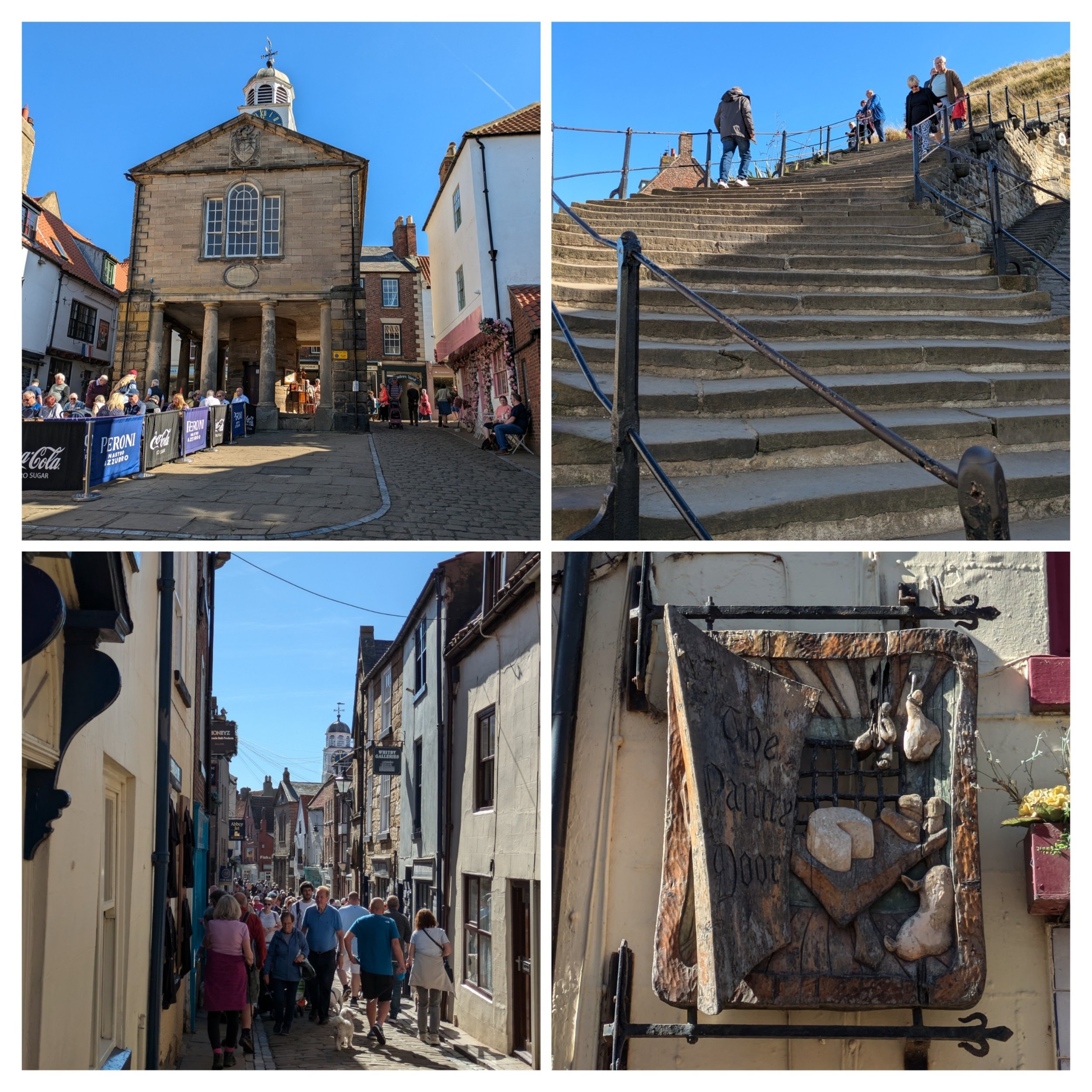
The old town hall was built in 1788 (top left pic) and the narrow, cobbled streets were bustling with visitors. I also spot this gorgeously carved shop sign for The Pantry Door. Always look up! I then make my way round to the famous 199 stone steps up towards St Mary's Church and Whitby Abbey.

I pause at the top of the steps to look back and take this photo of Whitby looking gorgeous in the sunshine. There is a cross is in the graveyard of St Mary's Church, it is Caedmon's Cross. a late Victorian-style Celtic cross that commemorates the famous 7th century Anglo-Saxon poet, Caedmon. He lived for most of his life at St Hilda’s monastic community of Streonaeshalch (Whitby), as a laybrother and herdsman. The cross is richly decorated on all four sides is almost 20 feet high and stands upon a solid stone-base. It was made from a hard type of sandstone quarried close by Hadrian’s Wall. Then there is Whitby Abbey itself, we visited the Abbey in 2020, so didn't feel it necessary to revisit it. If you'd like to read more about Whitby Abbey you can always read Steve's blog from our Clara and the Cathedrals trip. https://claraandthecathedrals.wordpress.com/2020/09/19/whitby-abbey/

Whitby Abbey was a 7th-century Christian monastery that later became a Benedictine Abbey. The first monastery was founded in 657 AD by the Anglo-Saxon era King of Northumbria, Oswy (Oswiu). He appointed Lady Hilda, Abbess of Hartlepool Abbey as founding abbess. The first incarnation of the Abbey under St Hilda lasted 200 years. At this time the North-East of England was invaded by the Danes. The invasion of the Danes wrought great destruction across the region and led to the fall of the Abbey. For the next 200 years, the Abbey was derelict, deserted, and destroyed by the ravages of time. The next incarnation of the Abbey was in the 11th century shortly after the Norman Conquest. It is these ruins that remain today. On the 14th December 1539, Henry VIII ordered Whitby Abbey to close. Upon closure, Whitby Abbey was stripped of all the fixtures and fittings of value; glass from the windows, lead from the roof and left to decay. The roof of the great church and the central tower all eventually fell.
The Cleveland Way continues opposite the abbey and now shares the same path as the King Charles III England Coast Path. The path here looks to have been renewed recently, great for a bit of speedy Nordic Walking to make up too much time spent wandering in Whitby!

I continue following the cliff path on towards Saltwick Bay and enjoy the great coastal scenery. I meet Steve just past the Whitby Holiday Village where there is some parking bays, you can access the beach here. The weather is still glorious and my lunch is consumed soaking up the sun on a picnic blanket outside the van.

Backtracking slightly to the clifftop path I pass fields of purple flowers which turn out to be a green manure plant called Phacelia, there are a few other plants including the odd sunflower! I took this photo of the beach at Saltwick from further around the path - looks to be a nice beach! There is evidence of coastal erosion and also of the extensive Alum shale quarrying that happened all along this coastline. This sea stack is called Black Nab.

Top pic is a fine example of how the landslips caused by excessive rain have literally left the path hanging in places. Here the path continues to follow the cliffs going through fields and passing this foghorn and a lighthouse. Whitby's Foghorns were sounded through a pair of ‘Rayleigh Trumpets,’ locally known as the ‘Hawsker Bull,’ It was operational from 1903 and remained in use until 1987. The equipment was updated in 1955. Each trumpet, 20 feet long and 8 feet high, was mounted on the engine room’s roof and set about 120º apart. Two horizontal 25-horsepower oil engines compressed the air needed to activate the horns. The siren blasted four times every ninety seconds and you could hear it up to 10 miles away.
The Whitby High Lighthouse, constructed in 1858, has safeguarded sailors for over a century. The Whitby High Lighthouse is the remaining half of a pair of towers initially positioned in a North-South alignment. They were collectively referred to as the twin lights of Whitby. Each lighthouse was furnished with paraffin lamps, and a pair of single-story keeper’s cottages were connected to each tower. The South Lighthouse is the only one that remains. The North lighthouse was demolished, and the foghorns took its place. Whitby High lighthouse was electrified in 1976 and the light was automated in 1992. The keeper’s cottages still stand and are available to rent.

Here the path climbs higher and then rolls gently up and down, sometimes with steps!

Boardwalks are also used in particularly wet or boggy areas. Near Hawkser the Coast to Coast path joins the Cleveland Way. I think the sign in the bottom pic might have been tampered with.

The National Trust is responsible for a lot of the coastal land along here and when the path isn't going through steep-sided wooded valleys the path is broad and grassy! "Two of the last two remaining rocket posts along our coastline were situated at Ravenscar and Robin Hoods Bay but eventually succumbed to age and the weather. Until very recently the only evidence still on the ground was the name of the field just north of Bay village where the National Trust sign announces Rocket Post Field. Firing a line from the cliff or shore in foul weather took a great deal of skill and in order to perfect this art the coastguard set up practice posts close to the coastal villages where they stored their apparatus. These 'rocket posts' were once a common feature along our cliff tops. Usually set in a field a short distance back from the cliff the post was topped by a metal crow's nest reached by simple step holds up the post. During practice sessions a coastguard would man the crow's nest to act as a mariner on a stranded vessel. The rescue team would then fire a line from 2 to 300 yards away to which was attached a heavier rope. If the shot was successful, the heavy rope was hauled in and secured and a breeches buoy attached. In a real life situation this would then be used to haul the crew, one at a time, to the shore." From geocaching.com

Walking around Ness Point, Robin Hood's bay is seen in the distance and I walk past the rocket posr.

Here the path turns right and joining The Cinder Track and old railway line that once linked Whitby to Scarborough. It's a 21.7 mile cycle track, but I'm only on it for a short while before turning onto Mount Pleasant North. Here the route has been permanently diverted. I'm meeting Steve in a car park near here and we wander down into Robin Hood's Bay together.

I've heard of Robin Hood's Bay but never been before, it's a picturesque old fishing village on the coast of the North York Moors. It apparently has a sandy beach, as well as rock pools to explore although the tide was in when we were there. We wandered down through its narrow, twisting cobbled streets and alleyways, it has a wide range of cafes, pubs, restaurants, small shops (most of these were already closed) and places to explore.
"The actual origin of the name remains a mystery. There is not a scrap of evidence to suggest that Robin Hood of Sherwood Forest folklore visited the Bay. The name is more likely to have grown from legends with local origin and probably from more than one legend. Robin Hood was the name of an ancient forest spirit similar to Robin Goodfellow and the use of the name for such an elf or spirit was widespread in the country. Many natural features were named after these local folk of legend and, in time, stories crossed over from one legend to another. The traditional anecdotes probably go way back in time but as to their origin - who knows?
What we are more certain of is that in the 18th century, Robin Hood’s Bay was reportedly the busiest smuggling community on the Yorkshire coast. Its natural isolation, protected by marshy moorland on three sides, offered a natural aid to this well-organised business which, despite its dangers, must have paid better than fishing.
Smuggling at sea was backed up by many on land who were willing to finance and transport contraband. Fisherfolk, farmers clergy and gentry alike were all involved. Fierce battles ensued between smugglers and excise men, both at sea and on land, and Bay wives were known to pour boiling water over excise men from bedroom windows in the narrow alleyways. Hiding places, bolt holes and secret passages abounded. It is said that a bale of silk could pass from the bottom of the village to the top without leaving the houses." from https://www.robin-hoods-bay.co.uk/about-rhb/history
We grabbed an ice-cream sundae from the shop with the post-office in on our way back to Clara!