
The Cleveland Way 2024: Day Nine
The Cleveland Way Nordic Walk, Wednesday 18th September 2024
Planned route: Robin Hood’s Bay to Scarborough
Official mileage: 13.78 miles
Strava mileage: 14.63 miles
Elevation gain: 1,893 ft
Moving time: 5:00:38
Steps: 33,584

The route today

Today is my penultimate day on The Cleveland Way and I'm walking into Robin Hood's Bay from the campsite Middlewood Farm where we've been staying the last couple of nights. It's a 15 minute walk, which is obviously well used with a good path all the way. Back in Robin Hood's bay the path brings me right to the National Trail path.

However before heading onto the path, I pop down to the seashore by the Bay Hotel as the tide is out. I also might have popped into a gift shop that was shut yesterday!

Norbert wanted his photo taken before we got too far today! Not far from there was this very old worn stone with a plaque giving the worn-out inscription. (little did I know there was sufferance to come!)

Walking up the steep Flagstaff Steps I turn right to climb up 100 more wooden steps. The path from here is paved in places and has obviously been suffering from landslips as there are some slabs hanging in mid-air! I look back over the beach and village behind.

My new friend Gary! I pass a field with several donkeys quietly grazing and make friends with one.

Eventually the easy path turns down steps into a wooded valley leading over a footbridge to Boggle Hole, a small cove where a stunning Youth Hostel sits (originally a corn mill). As I approach (looking for the loo) a guy says to me "you're Nordic Walking the Cleveland Way aren't you, you're putting some good stuff out on social media" fame at last! They were about to set off on one of their Festival of Walking social walks. There's also a cafe here.

Leaving Boggle Hole the path crosses a road and then goes up 100 steep steps to go along a lower cliff path before going back down, crossing a footbridge over Stoupe Beck. This then turns into a narrower track up yet more steps to a road beside a car park alongside Stoupe Bank Farm. I called this tree - last tree standing! Turning left I pick up the cliff path again.

There are views from here back to Robin Hood's Bay and the path is grassy again - I'm relieved for its flatter gradients!

Beautiful Gorse flowers on the way to Ravenscar. Gates and footbridges are the theme along this stretch which now heads inland.

Robin's Pincushion Gall on a Dogwood Rose, caused by wasps. The footbridges eventually lead past the Peak Alum Works.

Owned by The National Trust. the remains of Peak Alum Works are well preserved and give a good idea of the processes which took place. I can hear the famous Seal colony down on the beach below, but can't see them!
"Incredibly, there are over 300 seals in the colony living on the rocky beach at the foot of Ravenscar. The majority of the grey seal colony can be spotted further out on the large flat rock furthest away from the beach. If you take a pair of binoculars you can get a good look and watch them in their natural habitat – what a wonderful thing to see. Some of the seals will lounge on the beach right where the below route brings you out and you may spot some in the sea too. Both grey and common seals are found here, common seals are actually the less numerous of the two resident UK seal species. In Yorkshire, you are lucky enough to get to see both species." from the Whitby Guide
The 'castle' in the distance is Raven Hall. "Raven Hall was originally built by Captain William Childs of London. A Captain in the King's Regiment of light Dragoons, he first came to Yorkshire with the army. In 1763 Captain Childs became the owner of the Alum Works at Ravenscar and we assume that it is this commercial interest - combined with the breath-taking beauty of the area, which led him to build his family holiday home here. Until Raven Hall (which was formerly known as Peak Hall) was built in 1774, Ravenscar was a scattered hamlet of farm buildings. Staintondale was the main community in the area. However, there was in 1540 a large farm known as Peak house on the site of the 5th-century Roman fort, owned by a Mr John Beswick and his family. Nothing remains of the old fort except the foundations which were rediscovered during the building of Raven Hall." From Raven Hall Hotel

Here the path goes further inland rising through woodland and out on a track studded with locally made bricks until it reaches a road junction by the Raven Hall Country House Hotel. There's also a National Trust tearoom and coastal visitor centre here.

Cycling is popular in this area! Continuing along the main road past Raven Hall, the path is signposted left down a wide and very stony track to re-join the cliff top path.

The path continues on a grassy path undulating past fields and rugged cliff faces.

The path passes the remains of the local coastal defence radar system for the protection of the UK during the Second World War. It was one of a chain of stations built along the east coast during 1941 to detect approaching aircraft. There are four buildings. The site operated with about thirty RAF personnel on duty in shifts. All the buildings and the remains of the barracks are a Scheduled Monument. There is also a coast guard lookout. This was built in 1935 for the Auxiliary Coast Guard Watch but during the war, it was taken over as a War Watch Station which was connected by telephone to the radar station. It ceased to be used by the Coast Guard in 1972. I went up into this, but decided it looked to precarious to actually look out at the view!

At War Dike Gate there is a permissive path that I take as it enables me to meet Steve with Clara for lunch. It's the first up and over step stile I've seen on this walk, there were loads of them when I walked Hadrians Wall!

After lunch I continue to follow the regularly undulating path with good views of the headlands to come. At Hayburn Wyke the path descends steeply into a wooded valley using uneven stone steps and several flights of wooden steps which need to be navigated carefully, I also come across the only really bad stretch of muddy path on the whole 109 mile walk! Now crossing two footbridges bring me out at the top of the very bouldery beach and I make my way down to consider if I should swim there. There is also a waterfall that spouts out into a small pool on the beach, but the boulders are slippery, the tide is coming in and the waterfall pool looks dodgy, so I decide to carry on walking.

Boulders at Hayburn Wyke.

The tide is coming in over the slippery boulders and the slim waterfall at Hayburn Wyke, there wasn't great access to that pool either! These are the start of the stone steps that take you out of Hayburn Wyke and there are several twists and turns and more steps to reach the top.

A lovely tribute bench and small garden where I sat for a snack and to rest a while before continuing the relatively arduous rollercoaster of path between here and Scalby. The mileage on the signposts didn't decrease quickly enough and I was really feeling it in my legs - they had no va, va, voom.

Don't get me wrong this part was beautiful, it was just my body was struggling. I'm not sure if being able to see just how much farther you have to go helps.

Steps, steps ans yet more steps. It's the regular ups and downs that zap your energy, you have to concentrate on where your feet are going, also trying to make sure you're engaging your glutes for maximum help up each step!

It was nice to have a distraction every so often and something to read!
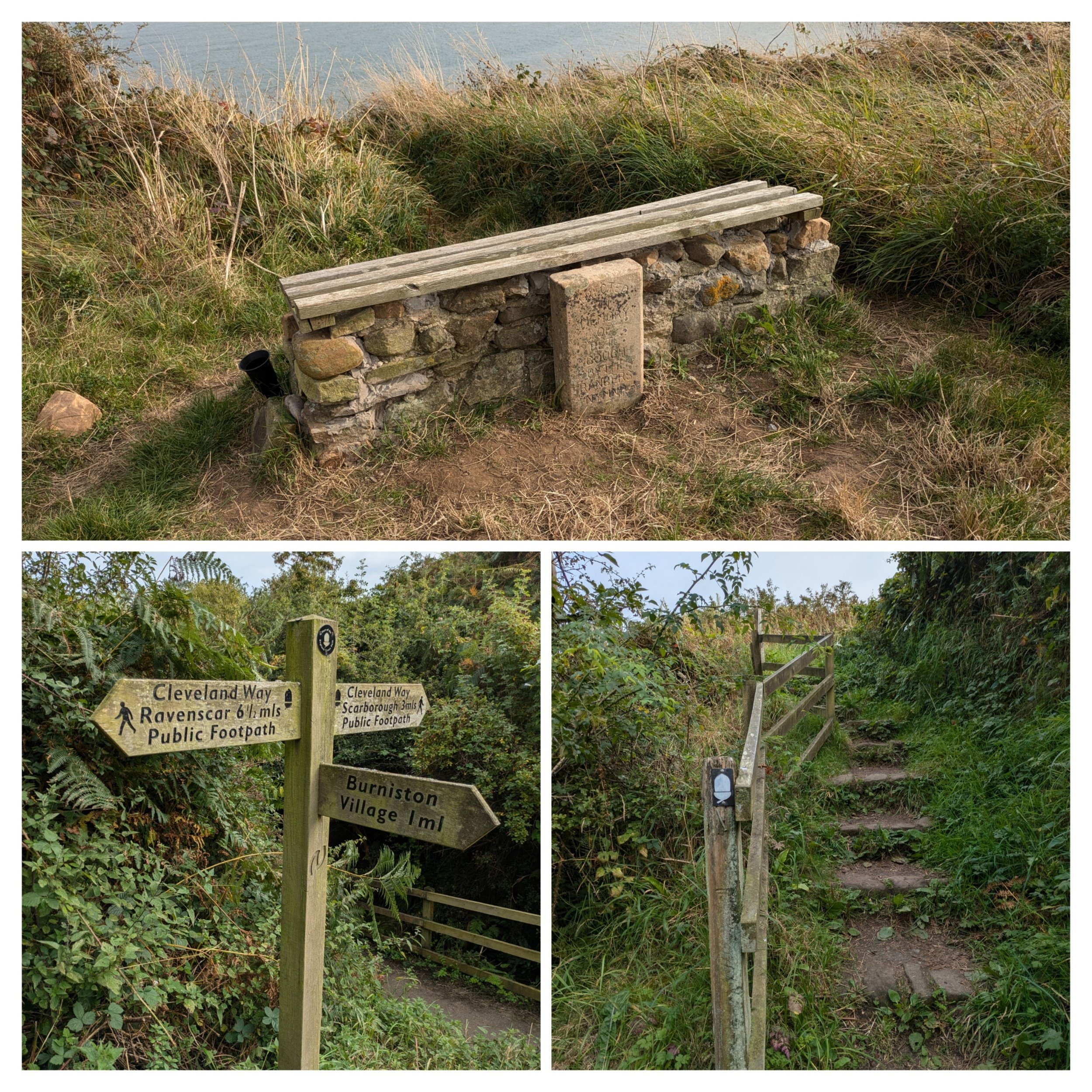
This bench was built by the North York Moors Rangers as a tribute to a colleague. Just 3 miles to go...'just' Oh look more steps.

Ahead I can see just how far away Scarborough appears to be, but in reality I don't really know just how many more flights of steps I will need to walk up and down or how many more fields I will pass. So I just have to dig deep and find my resilience. I stop and have another snack and a couple of jelly babies. There's lots of horsetail plants along here! It may be overcast, but it is quite warm and muggy.

I pass a signpost indicating the start of the Tabular Hills Walk which is a 48 mile walk that will take you back to Helmsley to make a circular route (another time maybe) for now I'd just like to get to Scarborough so I can stop for the day!

A walk around the final headland leads to 75 steps down to a bushy slope and then I can see Clara parked across the water at the Sealife Centre! Crossing the footbridge past the Old Scalby Mills Pub and I can stop! That was a hard day, I'm very relieved to see Steve and after stretching my stiff and tired body we head back to the campsite.
The river meets the sea here by the Old Scalby Mills Pub, further down where the sea crashes in it's not so still!