
The Cleveland Way 2024: Day Three
The Cleveland Way Nordic Walk, Wednesday 11th September 2024
Osmotherley to Clay Bank
Official mileage: 11.32 miles
Strava mileage: 12.34 miles
Elevation gain: 2,758 ft
Moving time: 4:41:29
Steps: 28,814

The route today
The guidebook describes this part of The Cleveland Way as ‘remarkably hilly, rather like a monstrous rollercoaster’ so strap in for the ride!

The day starts with blue skies and sunshine and I'm able to leave directly from the campsite today, leaving Steve to pack up and move on. It's a climb out of the campsite, but not before I get myself lost trying to locate the footpath out that I can see on the map, turns out it's the actual lane out that happens to have a footpath on it. I re-trace my steps from yesterday and pass the pinfold once more then taking a turn right along Ruebury Lane, signposted The Cleveland Way. The road climbs gently passing a few houses and comes to a fork where a footpath to The Lady Chapel is signposted. I decide to take the detour and along the footpath are stations of the cross, each with a different part of the story of Christ on them. Eventually reaching the top of the wooded hill, I come to a clearing.

The Lady Chapel is a Roman Catholic Chapel, attached to a house, said to have been built by Catherine of Aragon in 1515 for the recluse Thomas Parkinson. It is believed that a number of miracles have taken place here and the chapel remains a popular site of pilgrimage. I particularly liked the outdoor structure with big stone altar, very Aslan-esque! The chapel itself was small, simple, but pretty. Having taken the detour it was a relief to discover I didn't have to retrace my steps to re-join the path. There was a short path from the other side of the chapel to link back up with The Cleveland Way.

There are great views from the hillside and the path passes these pretty brown and white cows, too busy munching to take any notice of me saying hello.

Keeping straight on and through another gate, then the path starts to descend going through a gate into Arncliffe Wood. Here we meet the Coast to Coast Path and share paths for a while.

The path continues to undulate gently, then continues along the inside edge of woodland, hugging a beautiful dry-stone wall over the crest of a hill.

Norbert is sad that he can't get to this Trig point (299m) beause it is behind the dry-stone wall and barbed wire! Coming into view is the British Telecom station on Beacon Hill, it's argued that between the Trig point and here is the official start of The Lyke Wake Walk, which is a challenging 40-mile walk across the North Yorkshire Moors. It's considered one of the UK's oldest walking challenges and was once a popular choice in the 1970s and 1980s. No clue as to what the 6 brick plinths are for, answers on a postcard please.

Once past the BT station the path descends through a couple of gates to reach Scarth Wood Moor where heather grows in abundance. Major Herbert Peake, of Bawtry Hall in Doncaster, gifted the 220 acres or so of Scarth Wood Moor upon the National Trust back in 1935. In the distance the view takes in what is to come on following days on The Cleveland Way. Here the paths for the Coast to Coast and The Lyke Wake Walk all share the same route with The Cleveland Way path. The clear paved path rolls into the distance ahead of me, taking a turn down a much steeper slope heading down to reach a road.

A short walk down the road, crossing a cattle grid I take the next woodland path signposted to Huthwaite Green. Continuing along this path until a left-hand turn brings me to a commemorative stone to Bill Cowley.
"Bill was a former Indian Civil Servant, North Yorkshire farmer, local historian, journalist and broadcaster. In August 1955, he wrote an article, published in the Dalesman, suggesting the possibility of walking the 67km expanse of the North Yorkshire Moors National Park in less than 24 hours and The Lyke Wake Walk was born. In the fifty years that followed, it is thought over 160,000 people walked the Lyke Wake Walk - and during the peak of its popularity in the 60's and 70's as many as 15,000 walkers a year were completing the challenge. The volume of walkers however, started to have an impact on the surrounding land, and unfortunate damage started to occur to the delicate and fragile moorland ecology. Gradually over time more challenge walks became available to walkers, and the popularity of the Lyke Wake Walk lessened. Bill Cowley died in 1994, and with the agreement of the family of Bill Cowley and the majority of club members and officials, on the 1st October 2005 a final 'Golden Jubilee Wake' was held and the Lyke Wake Club was laid to rest, at the Raven Hall Hotel - fifty years to the day from where it had all started." from lykewakewalk.co.uk

Here the path walks down a flight of steps, it's steeper than it looks and I feel sorry for the mountain biker I meet at the bottom! Then follows a lovely flat, wide track perfect for a good stretch of Nordic walking.

Alongside the woodland path I spy teeny tiny mushrooms popping up and the elderflower trees are dripping with luscious dark purple berries. I also spot this hole in a tree and wonder who lives in there? It's a truly serene part of the walk.

The beautiful woodland walk pops out at the top of a grassy hill, gently descending to a track and I cross a wooden footbridge across a stream to continue up to a road, turning left to cross the river in the wooded valley of Scugdale. Here I continue up the road to come to a junction at Huthwaite Green where I am meeting Steve for lunch.

Norbert and I had a little wait for Steve to arrive and were very glad there was a bench and that it wasn't raining! A few walkers, runners and mountain bikers have passed by, I might have looked a bit weird with my shoes and socks off! After a lovely cuppa and lunch in the sun (mostly) I head off through the gate to the side of the signpost. Up another woodland path and I come across a scene of bleating sheep all following each other hurriedly the hill in the field to my left and a farmer on a quad bike hurtling down the path towards me. It's at this point I notice three sheep beyond the fence to my right, running downhill! Once past me the farmer leaps off the quad and over the fence, presumably they're not meant to be in there! So the group of sheep were rubbernecking their flock-mates on the escape!

Rubbernecking sheep on an ironstone spoil heap, woodland paths and fine views at the top.

The paths continue climbing through the heather less steeply on a stone-paved moorland path and levels out as it crosses the summit of Live Moor (312m). Amazing views across the North York Moors!

Dotted across the North York Moors are various standing stones, cairns, burial mounds, some with explanations others just guiding stones. This sign is how I know about the piles of stones actually being burial mounds!

The Cleveland Way paths continue to cross the moors undulating gently (for now) and then climbing up to Holey Moor. The weather is great for taking fantastic pictures showing off the beauty of this landscape.

I pass another Trig point at 408m on Carlton Moor, but daren't let Norbert have a photo as it is extremely windy, as you can tell from my new hairdo!
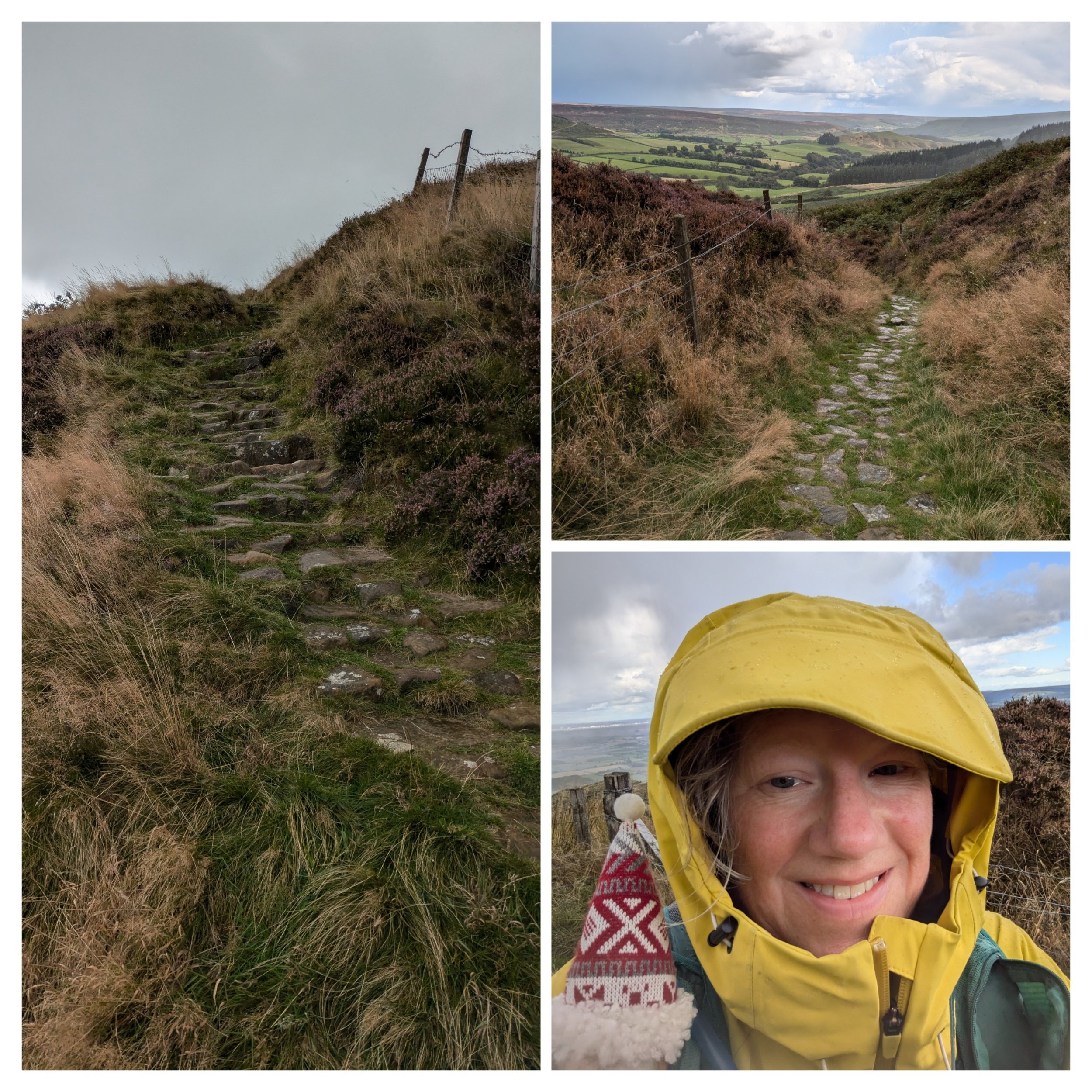
Here the path goes steeply down and the weather takes a turn for the worse and I put my phone away as I can literally see what is coming my way! What I hadn't realised was those rainclouds actually held freezing hailstones! The temperature plummets and I'm regretting the decision to leave my woolly hat and gloves in the van, thankful I have a raincoat, cap and rucksack cover, but I'm already too wet to put my waterproof trousers on!

I cross a road and pass through a small country park (which is very shut, no sign of the cafe or restaurant mentioned in the guidebook and the toilets are locked, there is also camping and glamping here apparently.) as the weather clears. The memorial stone I pass has me intrigued, I've not heard of The Samaritan Way, but apparently it's "A strenuous high-level route across the North York Moors National Park, crossing Commondale, Great Fryup Dale, Glaisdale and Farndale Moors to return via Westerdale, Baysdale and part of the Cleveland Way National Trail. This walk can be started anywhere but Guisborough is recommended." from the LDWA website.
After following a path out of the country park, I go through a gate to reach a paved path that continues alongside a drystone wall, when I get to Cringle End there is a viewpoint with a stone seat dedicated to local rambler Alec Falconer.
"Alec Falconer was a founder member in 1912 of the “Middlesbrough and District Countrywide Holidays Association and Holiday Fellowship Rambling Club” which went on to become known as the Middlesbrough Rambling Club. He was also an active campaigner for the rights of walkers under the pseudonym of “The Rambler” and was instrumental in the creation of The Cleveland Way which traverses Cringle Moor. He died a year before the trail was officially opened in 1969." Out and about website

The top image is the view from the stone seat previously mentioned. Here the path climbs higher on this fine gravelly path along the northern edge of Cringle Moor.

At least the sun has reappeared! The next section is steep and tricky to navigate with uneven stone steps, but there's brief respite in the form of a grassy path gently climbing. I go through a gate and the path begins to climb more steeply towards another summit on Cold Moor (401m) The weather closes in again, so quickly, but just rain and a freezing cold wind this time. The path drops downhill to another gate and grass.

Looking back from where I came.

I go through the gap and see rising before me yet another climb, but this one has jagged rocks at the top. These are known as the Wainstones. Long ago, or so the legend goes, a Danish chieftain met a sticky end amongst these rocky crags now known as the Wainstones, a name supposedly derived from the Old Saxon 'wanian,' meaning to lament.

It's not until you get closer that you realise you are going to have to scramble up through those jagged rocks to follow the path, literally on my hands and knees at a couple of points!

Top pic: the view back over the Wainstones Bottom pic: the relatively level stone paved path that follows it, flanked by heather.

Paved stones glinting in the post-downpour sunshine.

These paved paths are running along a moorland edge on Hasty Bank (390m), where these delightful Belted Galloway cattle are peacefully grazing.

What follows is a hideously steep descent down a narrow uneven stone path (apparently 60 steps), wet and tricky to navigate means a slow descent. They lead to the B1257 at Clay Bank where I am grateful Steve is waiting to collect me from a lay-by. I complete my usual post-walk stretches as especially today I have been up and down like a yo-yo and my quads have been like jelly on a few occasions. I reckon that was the toughest walk I have ever done. We drive to Little Ayton to find our campsite on Fletchers Farm and as we arrive there is a full double rainbow hanging over the hill ahead of us. Photo was taken through Clara's windscreen.

A beautiful sunset to end the day.